
Shared Access Problems an ALTA Survey Can Expose Before High-Density Development
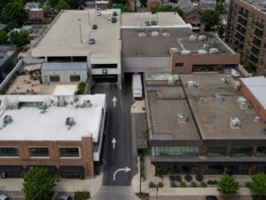
High-density development projects often depend on more than just the land they sit on, relying on shared drives, connected utilities, and access arrangements that stretch across property lines drawn decades earlier. An ALTA survey identifies these dependencies clearly before a project moves forward, giving the development team a full understanding of what the property actually relies on to function.
Discovering a critical dependency after construction has already begun creates far more disruption than catching it during the earliest planning stages, which is exactly what this kind of survey is designed to prevent.
Defining the Property Within a Connected Urban Site
Dense urban parcels rarely function in complete isolation, often relying on surrounding land for vehicle movement, utility service, or even basic pedestrian access. Understanding these connections requires looking beyond the immediate property boundary to the broader context surrounding the site.
This wider view helps a development team recognize just how interconnected the property truly is before committing to a redevelopment plan. A parcel that appears self-sufficient on a simple boundary drawing may actually depend heavily on neighboring land in ways that only become clear through careful research.
Mapping Shared Drives, Garages, and Loading Routes
Shared infrastructure is common in dense development, where separate buildings were often designed together to share driveways, parking garages, or loading routes rather than duplicating these features on every individual parcel. Mapping this shared infrastructure accurately shows exactly which improvements serve more than one owner.
This mapping matters directly for redevelopment planning, since any change to a shared drive or garage can affect neighboring properties that depend on the same infrastructure. Recognizing these relationships early helps avoid a design that inadvertently disrupts access relied upon by an adjacent owner.
Plotting Reciprocal Easements From the Title Documents
Reciprocal easements, where two or more properties grant each other rights over shared features, are common in dense development areas and need to be plotted carefully from the title documents. These arrangements often govern access, parking, utilities, or maintenance responsibilities shared between neighboring owners.
Understanding the full scope of these reciprocal rights helps a development team see exactly what obligations and benefits come attached to the property. A redevelopment plan that ignores these documented rights risks creating conflicts with neighboring owners who continue to rely on the original arrangement.
Checking Whether New Construction Interrupts Existing Use
Redevelopment plans need to be checked carefully against any shared corridors identified during the survey, since new construction could physically interrupt access currently relied upon by a neighboring property. This kind of conflict is far easier to resolve during design than after construction has already begun.
Identifying this risk early gives the development team the chance to adjust the plan, negotiate with the affected neighbor, or pursue whatever solution best protects the project while respecting existing rights held by adjoining owners.
Giving the Development Team a Single Access Reference
All of the access information gathered during the survey, from physical routes to recorded legal rights, comes together in one comprehensive reference document. This single source supports coordination across the legal, lending, and design teams working on the project.
Rather than each team member working from a partial understanding of the property’s access situation, a unified reference keeps everyone aligned on the same facts throughout the planning and development process.
Frequently Asked Questions
Can a shared driveway cross several parcels?
Yes. Its use may depend on one or more recorded access agreements connecting the properties involved in the arrangement.
Does an ALTA Survey determine whether an easement can be relocated?
No. Relocating an easement requires agreement and legal documentation from all the appropriate parties involved in the arrangement.
Should neighboring improvements be shown?
Relevant adjoining features may be located when they affect boundaries, access, or the specific Table A scope requested for the survey.
For a free land surveying quote, call us at (571) 200-9937 or send us a message by going here.
Posted in ALTA Survey
