
Mapping Public and Private Space Where Buildings Meet the Sidewalk
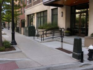
Mapping public and private space at the sidewalk sorts out a boundary that trips up many projects. The line between a private building and the public street is rarely where people assume, and the curb is not the answer. A survey draws that line precisely and records everything that crosses it, above and below the ground. That clarity keeps a frontage project legal and buildable.
Establishing the Right-of-Way Rather Than Assuming the Curb Is the Limit
Many people treat the curb as the edge of their property, but the real line sits elsewhere. The public right-of-way is a defined legal strip, and it often reaches past the sidewalk toward the building. A survey finds that line from the records, not the pavement.
Deeds, plats and street records hold the answer. The surveyor reads these alongside monuments and the physical street to fix the right-of-way. Sidewalk widths that vary along a block make this reading even more important.
Getting the line right shapes the whole project. Work planned on land the owner thought was theirs may actually sit in public space. Establishing the true limit first prevents that costly assumption.
Surveying Projections Above and Below Street Level
A building’s relationship with the street isn’t flat. Canopies, balconies and signs reach out overhead, while vaults, areaways and basement projections extend below. A frontage survey captures all of these, not just the ground-level line.
These projections carry rules of their own. A canopy over public space or a vault beneath the sidewalk may need specific permissions. Measuring them tells the design team what already exists and what a new project must respect.
Stairs and structural elements round out the picture. Steps that reach toward the street and framing that projects outward all get recorded. A complete survey shows the frontage in full, top to bottom.
Documenting Access and Accessibility Features at the Frontage
The frontage is where people enter a building, so access details matter. Entrances, ramps, landings and slopes all get measured, since a design has to meet accessibility rules. A slope that’s slightly too steep can fail a review.
Curb transitions and handrails add to the record. The survey captures where the walk meets the street and where rails guide people along a change in level. Clear-width measurements confirm there’s room to pass.
This data supports a workable design. An architect planning an accessible entrance needs the exact heights and slopes the survey provides. Accurate frontage measurements keep the design compliant from the start.
Locating Street Furniture and Utility Features
The space between a building and the street is crowded with fixed features. Poles, boxes, hydrants and meters all occupy the frontage, along with trees, grates, lights and signals. A survey locates each one that could affect the work.
These features constrain a design more than they seem to. A utility pole or a signal cabinet can block a planned entrance or driveway. Knowing exactly where they sit lets the design work around them.
Mapping them also aids coordination. Some features may need relocation, which involves other agencies and utilities. An accurate record starts that conversation on the right foot.
Creating a Three-Dimensional Frontage Record
A frontage this complex calls for more than a flat drawing. The survey combines plan views, profiles and cross-sections to show the space from several angles. Spot elevations pin down the heights that matter.
Point clouds and photographs add depth to the record. A laser scan captures the frontage in fine detail, while photos document conditions the drawings can’t fully convey. Together they give the design team a rich picture.
This layered record communicates a tight, constrained space. A designer working the frontage can study it without standing on the sidewalk. The three-dimensional record turns a crowded strip of ground into information a team can build from.
For a free land surveying quote, call us at (571) 200-9937 or send us a message by going here.
Posted in Boundary Surveying
