
How Property Surveys Help Verify Existing Site Improvements
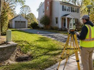
Walk an older parcel and you’ll spot things the paperwork forgot. A shed in the back corner. A driveway someone widened years ago. A utility box that shows up on no plan you were handed. Property surveys exist to sort out that mismatch, lining up what sits on the ground with what sits in the record. Any team planning a build wants that mismatch solved before the first line goes on a drawing.
Coverage is the whole idea. A survey pins down every existing improvement and its exact spot on the parcel. That single record is something your team, your lender and the county can all stand behind.
Why Existing Site Improvements Should Be Verified Before Planning
Old drawings lie more often than people expect. A parcel changes over the years. Buildings get added, pavement shifts and utilities go in without ever reaching the official record.
Planning off stale data is a costly bet. You might place a new building over a utility line you didn’t know was there. You might assume a setback you don’t actually have. Small errors like these grow once construction starts.
Verifying first removes the guesswork. A current survey shows the real position of every improvement on the site. It confirms how those improvements relate to your lines, setbacks and easements. With that in hand, your design starts from truth instead of hope.
How a Property Survey Documents Existing Site Improvements
A property survey measures and maps what already exists on a parcel. The surveyor locates each improvement and records its exact position. Those positions get tied to the boundary lines and a known elevation.
The work follows a clear sequence:
- Research the deed, plat and any prior surveys for the site.
- Set control points that anchor every measurement to one baseline.
- Locate buildings, pavement, utilities and other features in the field.
- Measure how each feature sits against boundary and setback lines.
- Draw the results on a signed map that shows the site as it stands.
Modern crews use GPS, total stations and sometimes drones to capture the data. The output is a measured drawing, not a sketch from memory. Each feature has a real location you can design against. A licensed surveyor signs the map, which gives it weight with the county and your lender.
Common Improvements Surveyors Record During Field Work
Field crews record far more than the main building. Anything that affects how you use or build on the site can matter. The goal is a full picture of what’s already there.
Surveyors typically locate:
- Buildings, additions and their footprints.
- Driveways, parking, sidewalks and other paving.
- Fences, walls and retaining structures.
- Visible utilities like manholes, meters, hydrants and poles.
- Drainage features such as inlets, pipes and swales.
- Site features like decks, pools, signs and light poles.
Each item gets a location and, where it matters, an elevation. That lets you see which improvements sit near a line or inside an easement. Crews also note where a structure appears to cross a boundary. Catching an encroachment on paper beats discovering it mid-project.
How Verified Site Information Supports Better Project Decisions
Good site data drives better calls at every stage. You design with confidence when you know where everything sits. You also spot conflicts while they’re still cheap to fix.
Verified survey data helps you:
- Place new buildings where they clear setbacks, easements and existing utilities.
- Size your usable area based on real conditions, not the old plat.
- Spot encroachments before they turn into legal disputes.
- Plan around utilities instead of relocating them mid-build.
- Give designers and reviewers one trusted source for the site.
For a developer, that clarity keeps a project moving. Fewer surprises mean fewer change orders and delays. It also strengthens your case during permitting, since reviewers can see the real site. A plan grounded in current data holds up better than one built on assumptions.
When a Property Survey Should Be Updated Before New Projects
An old survey can be worse than none, because it looks trustworthy while being wrong. Sites change, and the paper needs to keep up. Update the survey before you lean on it for a new project.
Get a fresh or updated survey when:
- The last survey is several years old or its age is unknown.
- New buildings, pavement or utilities have gone in since then.
- You’re buying, refinancing or planning a major build.
- A lender or the county asks for current site conditions.
- You see fences, structures or drainage that the old map doesn’t show.
The update confirms what’s changed and re-ties everything to current lines. It gives your team a starting point they can rely on. That small step up front prevents big corrections after work begins.
Frequently Asked Questions
What does a property survey show about existing improvements?
A property survey shows where each improvement sits on the parcel. That includes buildings, pavement, fences, walls and visible utilities. The map ties every feature to the boundary lines and setbacks. It also flags anything that appears to cross a line or sit inside an easement.
How is this different from a boundary survey?
A boundary survey mainly marks where the property lines run. A survey that verifies improvements also locates the structures and features on the site. It shows how those improvements relate to the lines, setbacks and easements. Many projects need both the boundary and the existing conditions on one map.
How often should a property survey be updated?
There is no fixed expiration, but older surveys lose value as a site changes. New construction, added pavement or fresh utilities can make an old map wrong. Lenders and reviewers often want current conditions for a new project. Update the survey whenever the ground no longer matches the paper.
Can a property survey find encroachments?
Yes. Locating improvements against the boundary is how encroachments turn up. The survey shows when a fence, wall or building crosses a line. Finding that early lets you resolve it before it stalls a project or sparks a dispute.
Do developers need this survey before every project?
Not every job requires a full new survey, but most benefit from current data. Larger builds, purchases and permit submissions usually call for verified conditions. Skipping it on a changed site invites costly surprises. A surveyor can advise whether an update or a new survey fits the project.
For a free land surveying quote, call us at (571) 200-9937 or send us a message by going here.
Posted in land surveying, land surveyor | Tagged boundary survey
