
How LiDAR Mapping Helps Survey Wooded Development Sites
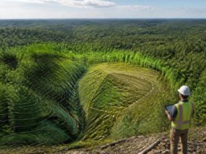
Try running a survey line through five acres of thick woods. The tape snags. The sight line dies at the first tree. Brush hides every dip and rise in the dirt. LiDAR mapping gets past all of that by firing laser pulses that slip through gaps in the leaves. Paired with traditional property surveys, it turns a tangled lot into a clean read of the real ground. A heavily wooded parcel is exactly where this tool earns its keep.
The ground under the canopy still has a shape. LiDAR shows that shape without clearing a single acre first. That head start changes how you plan, budget and protect the site.
Hidden Terrain Features That Dense Vegetation Can Conceal
Trees do a good job of hiding what the ground is doing. From the road, a wooded lot can look flat and simple. Walk it, and the story often changes.
Heavy cover can mask features that drive your whole design:
- Steep slopes and hidden ravines that limit where you can build.
- Small streams, seeps and wet areas that trigger buffers and permits.
- Old drainage channels that carry water across the site.
- Depressions and low spots that pond after rain.
- Leftover features like old foundations, wells or fill piles.
Miss these, and your plan fights the land instead of working with it. A building pad lands on a slope you didn’t measure. A road crosses a stream you never saw. LiDAR brings these features into view before they wreck a budget.
LiDAR Mapping Techniques for Capturing Ground Elevation
LiDAR stands for light detection and ranging. A sensor sends out laser pulses and times how long each one takes to bounce back. From a drone or aircraft, it fires many thousands of pulses a second across the site.
In the woods, one detail makes it work. A single pulse can split into several returns. Some bounce off the top of the canopy. Others slip through gaps and reflect off branches, then finally off bare earth. The surveyor keeps those last returns to build a bare-ground model under the trees.
The raw output is a dense point cloud. Software then filters out the vegetation and leaves the ground surface behind. Ground control points check the data against known elevations for accuracy. The result is a set of contours and a terrain model you can design against, even where a crew could barely walk.
Terrain Data That Supports Smarter Development Decisions
Clean terrain data feeds almost every early decision on a wooded site. You stop guessing about the ground and start planning against measured numbers. That shift shows up across the whole project.
Good LiDAR terrain data helps you:
- Set building pads where the grades actually support them.
- Design drainage and detention that match how water really moves.
- Route roads and access to work with the slopes, not against them.
- Estimate cut and fill before you price the earthwork.
- Spot constraints early, so they shape the plan instead of blocking it.
For a developer, that means fewer nasty surprises once machines arrive. The layout you draw has a real chance of holding up in the field. Better input at the start cuts expensive redesigns later.
Environmental and Design Benefits of Early Site Mapping
Mapping a wooded site early pays off beyond the grading plan. It gives you a way to build with the land’s limits in mind. That protects both the site and your schedule.
With terrain and feature data in hand, you can steer clear of the sensitive spots. Streams, wetlands and steep slopes get flagged before design locks in. You can save stands of trees worth keeping and clear only what the plan needs. Less blind clearing means less erosion and fewer permit fights.
Early data smooths the approval path too. Reviewers can see that your plan respects drainage and buffers. That trust can shorten back-and-forth during permitting. A project that starts with honest site data tends to move faster than one that guesses.
Choosing LiDAR Mapping for Large Wooded Properties
LiDAR shines most on the sites that give ground crews the hardest time. Big acreage and thick canopy are the clearest case. The harder the site is to walk, the more the method pays back.
Consider LiDAR mapping when:
- The property is large and covered in dense trees or brush.
- The terrain is steep, cut by ravines or hard to reach on foot.
- You need terrain data fast to keep a project on schedule.
- Sending crews through heavy brush raises real safety concerns.
- You want full coverage instead of scattered spot elevations.
A licensed surveyor should still run the job and verify the data with ground control. LiDAR is a tool inside a real survey, not a replacement for professional judgment. Used that way, it gives large wooded sites a level of detail that older methods struggle to match.
Frequently Asked Questions
Is LiDAR accurate enough to survey ground under tree cover?
LiDAR can capture bare-ground elevations under canopy that other methods miss. It works by keeping the laser returns that reach the ground through gaps in the leaves. Ground control points then check the data against known elevations. When run by a licensed surveyor, the terrain model is accurate enough for real design work.
Does LiDAR mapping replace a traditional property survey?
No. LiDAR is a tool that supports a survey, not a stand-in for one. A licensed surveyor still ties the data to boundaries, control and the legal record. The technology captures terrain fast, but the professional work around it is what makes the results usable.
What is the difference between aerial and ground-based LiDAR?
Aerial LiDAR flies on a drone or aircraft and covers large sites quickly from above. Ground-based LiDAR scans from a tripod and captures fine detail from the surface. Wooded development sites often use aerial LiDAR for broad terrain coverage. The surveyor picks the method that fits the site and the goal.
How much of the ground can LiDAR see through dense trees?
The amount of ground data depends on how thick and open the canopy is. Bare winter branches let more pulses reach the earth than full summer leaves. Even in heavy cover, enough pulses usually slip through to model the ground. The surveyor plans the flight and settings to get the best coverage possible.
Is LiDAR worth it for a small wooded lot?
On a small, easy lot, traditional ground methods may be all you need. LiDAR earns its cost on large, steep or heavily wooded sites that are slow to walk. The bigger and rougher the property, the more the coverage pays off. A surveyor can tell you whether LiDAR fits your specific site.
For a free land surveying quote, call us at (571) 200-9937 or send us a message by going here.
Posted in land surveying, land surveyor | Tagged LiDAR Mapping
