
Can Boundary Surveying Show Whether a Residential Lot Qualifies for Expanded Housing?
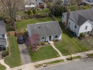
Boundary surveying provides the measured facts that a residential lot needs before anyone can judge it for expanded housing. Many places now allow homeowners to add units, build a second home or divide a property in ways the old rules blocked. Whether a specific lot qualifies depends on its exact size, shape and existing conditions. A survey supplies those numbers, though it stops short of guaranteeing that any project gets approved.
Verifying the Recorded Dimensions of the Parcel
The starting point is confirming the lot’s actual dimensions, which often differ from what people assume. The survey measures the real width, depth, area and shape of the parcel. Recorded figures from an old deed can be off, and expanded housing rules usually hinge on precise numbers.
Area is frequently the deciding factor. A rule might require a minimum lot size for a second unit or set a certain area per dwelling. A parcel that appears large enough on paper may fall short once measured, or the reverse may turn out to be true.
Shape matters alongside size. Two lots with the same area can offer very different possibilities depending on how they’re shaped. A long narrow lot fits housing differently than a square one. The survey captures the geometry that determines what actually works on the ground.
Locating the Existing Home and Other Improvements
The survey maps everything already on the lot, since existing structures shape what can be added. Crews locate the house, garage, porches, additions, patios and any accessory buildings. Each one takes up space and affects where new construction can go.
Those improvements reduce available room quickly. A house with a large footprint, a detached garage and a wide driveway can leave little space for another unit. The survey shows precisely how much of the lot the existing structures occupy.
Placement matters as much as size. A house sitting in the center of a lot creates different opportunities than one pushed to one side. Knowing exactly where every structure sits lets an owner and designer see where an addition or a new unit could realistically fit.
Measuring Available Space Around the Current Structure
Beyond locating the buildings, the survey measures the open space around them. Setbacks, side yards and rear yards all determine where new construction can happen, and the survey quantifies each one.
Side yards often prove tight. On a typical residential lot, the space between the house and the side property lines may be too narrow for much of anything. The survey shows whether those areas can support a unit, a parking space or an access path.
Rear yards usually offer the most potential. Many expanded housing options place a new unit behind the main house, so the depth and width of the backyard become critical. The survey measures that space against the setbacks to show what remains buildable.
Identifying Easements and Access Limitations
Easements and access issues can quietly disqualify a lot, so the survey looks for them. Utility easements, drainage easements and shared access rights all reduce the space an owner can actually use, even when the lot looks big enough.
An easement in the wrong place changes everything. A drainage easement crossing the backyard may sit exactly where a second unit would go. Building over many easements is prohibited, so finding them first prevents a plan built on unusable ground.
Access can be a hidden problem too. A lot that depends on a shared driveway, or one with limited street frontage, may struggle to provide the access a second unit needs. The survey documents these limitations so they factor into the analysis from the start.
Preparing an Accurate Exhibit for Zoning Review
The survey produces the exhibit that supports a zoning conversation. It shows the boundary with dimensions, the lot area, the existing structures with setback measurements, and the easements and access features. Reviewers and designers work from this document.
That exhibit answers the questions officials ask. They check lot size, coverage, setbacks and access against the rules for expanded housing. An accurate survey lets them evaluate the request based on real measurements rather than estimates.
The survey informs the decision without making it. It provides the facts that a homeowner, an architect and the zoning authority use to determine whether a project qualifies. Approval still depends on the rules and the review, but that process runs on the measured information the survey supplies.
Frequently Asked Questions
Does a boundary survey decide whether a property qualifies for expanded housing?
No. The survey provides the measurements that qualification depends on, such as lot size, setbacks and available space. The zoning authority applies the rules to those facts and makes the decision. The survey gives everyone accurate information to work from, but approval comes from the review process, not the survey itself.
Can an old house location survey be used for a new development proposal?
Sometimes as background, though often not as the primary document. An older survey may miss features, use outdated measurements, or lack the detail a new proposal needs. Conditions also change over time. A current survey usually gives designers and reviewers the accurate, complete picture that an expanded housing proposal requires.
Will the survey show shared driveways and recorded access rights?
Yes. A boundary survey locates physical features like shared driveways and plots recorded access rights such as easements. These matter for expanded housing because they affect how a new unit reaches the street and how much usable space the lot really has. Showing them helps everyone understand the property’s real limitations.
For a free land surveying quote, call us at (571) 200-9937 or send us a message by going here.
Posted in Boundary surveying
